File:Forms of government.svg
Jump to navigation
Jump to search

Size of this PNG preview of this SVG file: 800 × 406 pixels. Other resolutions: 320 × 162 pixels | 640 × 325 pixels | 1,024 × 520 pixels | 1,280 × 650 pixels | 2,560 × 1,300 pixels | 2,754 × 1,398 pixels.
Original file (SVG file, nominally 2,754 × 1,398 pixels, file size: 1.11 MB)
Captions
Captions
Official forms of government
Summary[edit]

|
This file may be updated to reflect new information. If you wish to use a specific version of the file without new updates being mirrored, please upload the required version as a separate file. |

| Description |
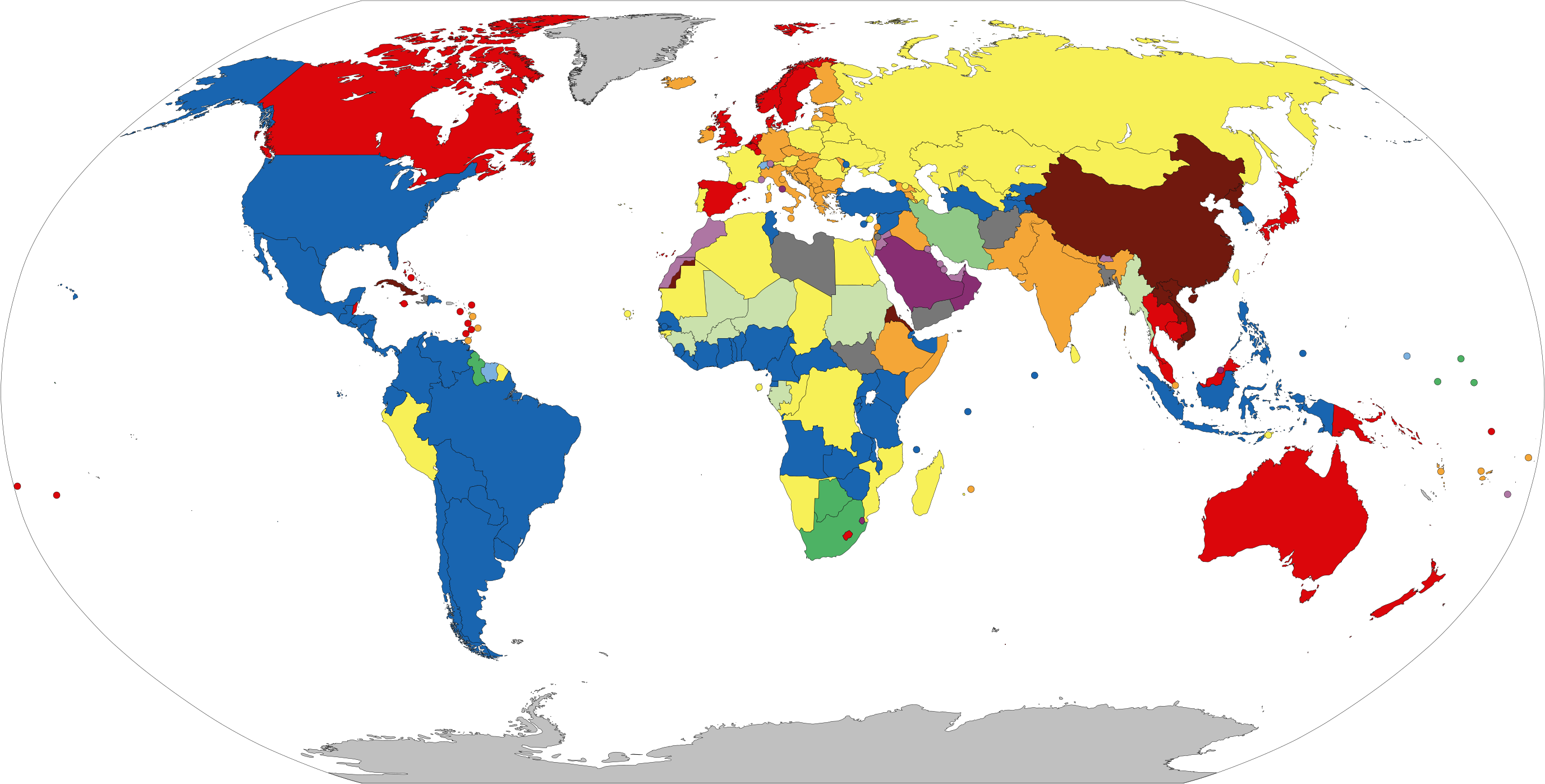
English: English (en): World's states coloured by form of government.
Republics with an executive presidency elected by or nominated by the legislature. Parliamentary constitutional monarchies in which the monarch does not personally exercise power (except perhaps reserve powers). Dual system constitutional monarchies in which the monarch personally exercises power (often alongside a weak parliament). Countries in which constitutional provisions for government have been suspended (e.g. military juntas). Countries which do not fit any of the above systems (e.g. transitional governments). No government.
Note that several states constitutionally deemed to be multiparty republics are broadly described by outsiders as authoritarian states. This chart aims to represent
de jure form of government, not de facto degree of democracy. |
| Date | |
| Source | Own work |
| Author | Newfraferz87 |
| SVG development |
Legend[edit]
English (en): World's states coloured by form of government.
Republics with an executive presidency elected by or nominated by the legislature.
Parliamentary constitutional monarchies in which the monarch does not personally exercise power (except perhaps reserve powers).
Dual system constitutional monarchies in which the monarch personally exercises power (often alongside a weak parliament).
Countries in which constitutional provisions for government have been suspended (e.g. military juntas).
Countries which do not fit any of the above systems (e.g. transitional governments).
No government.
Note that several states constitutionally deemed to be multiparty republics are broadly described by outsiders as authoritarian states. This chart aims to represent
de jure
form of government, not de facto
degree of democracy.
Licensing[edit]
I, the copyright holder of this work, hereby publish it under the following license:
| This file is made available under the Creative Commons CC0 1.0 Universal Public Domain Dedication. | |
| The person who associated a work with this deed has dedicated the work to the public domain by waiving all of their rights to the work worldwide under copyright law, including all related and neighboring rights, to the extent allowed by law. You can copy, modify, distribute and perform the work, even for commercial purposes, all without asking permission.
|
File history
Click on a date/time to view the file as it appeared at that time.
| Date/Time | Thumbnail | Dimensions | User | Comment | |
|---|---|---|---|---|---|
| current | 08:26, 27 October 2023 | | 2,754 × 1,398 (1.11 MB) | GlowstoneUnknown (talk | contribs) | Reverted to version as of 15:55, 21 October 2023 (UTC) De jure statuses of *de facto* nations, and overseas territories/possessions aren't meant to be marked. Transnistria is a de facto state that considers itself a Presidential Republic, that's why it's present on this map. |
| 07:36, 27 October 2023 |  | 2,754 × 1,398 (1.06 MB) | UA0Volodymyr (talk | contribs) | Reverted to version as of 07:31, 20 October 2023 (UTC) It doesn't matter. The description says that this chart aims to represent de jure form of government, not de facto, and deffinatelly not what de jure recognized as military occupation | |
| 15:55, 21 October 2023 |  | 2,754 × 1,398 (1.11 MB) | Clyde H. Mapping (talk | contribs) | Reverted to version as of 11:18, 17 October 2023 (UTC) List article the map is based on includes states with limited recognition | |
| 07:31, 20 October 2023 |  | 2,754 × 1,398 (1.06 MB) | UA0Volodymyr (talk | contribs) | Reverted to version as of 10:10, 17 October 2023 (UTC) unexplained | |
| 11:18, 17 October 2023 |  | 2,754 × 1,398 (1.11 MB) | ICommandeth (talk | contribs) | Reverted to version as of 07:17, 17 October 2023 (UTC) | |
| 10:10, 17 October 2023 |  | 2,754 × 1,398 (1.06 MB) | UA0Volodymyr (talk | contribs) | Reverted to version as of 17:25, 6 October 2023 (UTC) please write reason for reverting my changes in the Talk page | |
| 07:17, 17 October 2023 |  | 2,754 × 1,398 (1.11 MB) | ICommandeth (talk | contribs) | Removed Artsakh since it doesn't control any territory | |
| 09:26, 16 October 2023 |  | 2,754 × 1,398 (1.11 MB) | ShadZ01 (talk | contribs) | Fixed Kazakhstan as a semi-presidential republic | |
| 04:14, 10 October 2023 |  | 2,754 × 1,398 (1.11 MB) | GlowstoneUnknown (talk | contribs) | Whoops uploaded the wrong version of the file | |
| 04:11, 10 October 2023 |  | 2,754 × 1,398 (1.11 MB) | GlowstoneUnknown (talk | contribs) | Transnistria is de jure a full presidential republic according to its own wikipedia page |
You cannot overwrite this file.
File usage on Commons
The following 4 pages use this file:
File usage on other wikis
The following other wikis use this file:
- Usage on ar.wikipedia.org
- Usage on av.wikipedia.org
- Usage on bn.wikipedia.org
- Usage on bxr.wikipedia.org
- Usage on cs.wikipedia.org
- Usage on da.wikipedia.org
- Usage on de.wikipedia.org
- Demokratie
- Republik
- Monarchie
- Diktatur
- Konstitutionelle Monarchie
- Militärdiktatur
- Regierungssystem
- Politisches System
- Präsidentielles Regierungssystem
- Parlamentarisches Regierungssystem
- Semipräsidentielles Regierungssystem
- Einparteiensystem
- Direktorialsystem
- Vorlage:Regierungssysteme der Welt
- Portal Diskussion:Politikwissenschaft/Bild des Monats
- Wikipedia:Kartenwerkstatt/Archiv/Zurückgewiesene und zurückgestellte Aufträge 2010
- Diskussion:Bahamas/Archiv
- Diskussion:Republik/Archiv
- Wikipedia:Kartenwerkstatt/Archiv/Zurückgewiesene und zurückgestellte Aufträge 2012
- Benutzer:Kopiersperre/Westermann Orient
- Wikipedia:Kartenwerkstatt/Archiv/2014-08
- Diskussion:NS-Staat/Archiv/002
- Wikipedia:WikiProjekt Demokratie/Entwicklung
- Wikipedia:Café/Archiv 2016 Q4
- Wikipedia:Auskunft/Archiv/2022/Woche 32
View more global usage of this file.